overland cali
aka the ring of fire
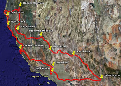
That name seems to fit if you look at these maps:
My route
And a NASA photo of the wildfires last week

This is the longest journey so far… by far. And probably the last for a long time… I think I've expended all my "escape from reality" tickets. If Cloud 9 is a thick mixture of pine smoke and ocean fog, then I was definitely "in it" for a good long time in June 2008
I shook my crusted jacket out over the living room and four or five different sheets fell out… all of them full of scribbled memories, hand drawn maps, phone numbers and e-mails from some of the cool folks I met along the way, and even the first half-line of a poem… (I wasn't really feeling it at the time and ended up looking at the stars instead)
I don't want this to be long… but I am a horrible self editor. Besides, a gentleman I met on this trip reminded me that I will be grateful, down the real road, when I can look back at pictures and blurbs… since I am already starting to forget...
In total my motorcycle (which has a name now thanks to a great recent Disney flick) was on the road for 5 weeks. So throughout 3,036 miles and one saddle change on the bike, here's what happened…
The sun's tall over ocean
The pens hold up your hair
A California coastline
I swore I wouldn't care
I find it hard to turn you off
When you're not here
And I find it hard
To tune you out, to disappear…
The genesis of this thing actually occurred after I had begun the first leg. It transpired inside my bean, which was droning on the interstate towards Phoenix about 6 feet above the asphault and piecing together a loose itinerary. Noting people and places to see after the intermission in AZ, I couldn't help but grin under the Kevlar faceshield
During the short Arizona break I drove back to Cali in my brother's car and managed to find sailing in the desert… if any of you identify with my love of wind and sadness at leaving the gulf of mexico, then you'd understand when I say "groovy"

But riding puffs on the flats wasn't really part of the journey, so I'll begin back at that first leg… from Edwards to Phoenix...
Before going to Arizona I had to visit a little town called Perris, so I kinda half-googled a map and went on my way through the San Angeles mountains… pretty much the long way around
Route 2 is full of tight turns and piney atmosphere... and it happens to be, as I would discover after zipping 30 miles into the fray, closed due to washout. I stopped at a biker bar to stretch my bum muscles (medical term) and prepare for the half hour long mirror image drive back out of the mountains
After finishing a delicious California burger (it had avocado on it, so it had to be healthy), another biker offered to lead me to the trailhead for a "shortcut" out of the mountains, which would circumvent the open part of 2 I had already ridden. One lane dirt road… why the heck not
Two hours later, I found myself still on (I think) the same road at the base of Mt Pacifico... no map in hand and wondering if the gallon in my tank was gonna be enough. Well yikes, I might as well run out of gas on top of Pacifico… so I took a right into the mountain and first-geared it up the rocks to the top…

Okee dokee, well I can see Edwards from up here…couple fellas on quads gave me directions up on the mount and I headed back the same way as they finished their beers. An hour later, they blasted right by me on the single lane road. If an empty beer can had hit my face, I wouldn't have been surprised! I was glad I could see the road exiting the mountain below…

After finishing up my errand in Perris, I wound through the San Bernardino forest and trickled onto I-10 near Palm Springs... and the droning and planning commenced for the next 3 hours. Two weeks later, I took off from Phoenix to Vegas… and the real fun began

Hoover Dam is low on power. You can see the gradually receding water line on the reservoir cliffs. The dam is also unfriendly to trucks and large movers. So some very skilled folks are building an "engineering masterpiece" of a bridge above to convert this highway into a shipping route. So get your "I stood on top of Hoover Dam" fix over with before it's too late
After hanging out with my old roommate in Sin City and catching a wicked Soleil show, I drove by Red Rocks on my way back into Cali. I wasn't expecting the next two weeks of driving to be 75 percent through smoke… I'm glad I went in with an open mind

The entrance to California from Las Vegas is Death Valley. Its lowest point is almost 300 feet below sea level. I had to continually let air out of the tires during my half day here… the temperature is 120


Weather systems do not venture below sea level. So the sun has a wonderful, windless opportunity to heat up the valley like a giant stir fry pot. I was an 80 mile-an-hour water chestnut on this day…

Spotting another dirt road along the valley floor, I pulled off and tore up into a small mountain off to one side. I was fully loaded with clothes, water, and supplies for two weeks of driving… the bike still performed marvelously on the Martian terrain

This is the reward for taking foolish paths into the mountains… glad I learned that lesson back on Pacifico. I ran out of water half an hour's walk into this thing, but saw enough to enjoy it. And left a little rock Dan in the canyon to greet future citizens of Cloud 9. Seeing all the little rock people reminded me of a neat movie I saw at the Banff film festival a couple years ago with Randy and Tara

And now here's the neat part...

70 miles west of the valley is the highest point in the US. Mt Whitney and her brothers. And Sequoias on the other side of them. I completely lost my disappointment of not seeing any cattle skulls as soon as the temperature dropped 50 degrees and I saw the town of Lone Pine with this backdrop in front of me. Met a few thru-hikers who were halfway through a 5 month stick through the Pacific Crest Trail. That trail, on foot, is almost as long as my entire moto trip. My toe throbbed a gentle painful reminder as I dreamed of joining these walking machines and going AWOL for 3 months towards Canada!

I turned north, and rode the beautiful 395 up through crispy pine weather. As I got closer to my 8,600 foot high campsite, I regretted not bringing my jacket liner


Tuolumne Meadows make up the eastern side of Yosemite... the side you don't see in any of the postcards. A 40 degree night waited for me up there, so I experienced the hottest and coldest moments of the trip in one single gorgeous day

Why does the planet have to go and rotate while I try to figure out these long exposure settings on the camera???

I'm living in an age
That calls darkness light
Though my language is dead
Still the shapes fill my head

Here's the thing about morning, especially when you sleep under the sky. You wake up before Sol makes it over the horizon. Something about the twilight caressing your eyelids creates a general ambience inside your brain. I slowly roll up my bag and shuffle off, so as not to disturb the tent dwellers I met last night. Good group, up here from Orange County. Their boy has never been camping before. I bet he is awake in one of those tents. He still gets it
Whenever there is a sunrise, that is where I want to be. I hope that makes sense (c'mon Marty, think fourth dimensionally!)
Lake Tenaya is where I was


Wish you had been there Mike, I can't do it justice

I lived in this house… a long time ago. So strange seeing the far past sometimes. I know this picture only has meaning to me and my family, but I wanted to put it up
I spent a few days being spoiled at another home. That of an old college bud's parents. He and I caught up, slapped hands, and then it was off to wine country (Napa). And there is where the ring found the fire
The vineyards were eerily immersed in a soup of smoke. I read afterwards that people have been going to hospitals with lung damage. I thankfully blew threw fairly quickly. My plans of a multi-day Sideways style passage would have to be put on a raincheck
The next three days I made it all the way up to Redding. I entered the world's most famous saddle shop. I smiled big, pleaded some, and skipped a three month waiting list… and before setting out towards the coast I had a custom made seat under me!
While it was built I ventured 15 miles north to find a fabled dirt road that led to a ranger tower. I discovered the road, only to find it blocked one mile from the top. I started walking, like that day in the canyon. But this is mountain lion territory, and as I looked up at the rocks it strangely reminded me of the same stony perches you see elk walking under in those extreme nature videos. I am scared to death of fauna… ask anyone I have swum in the ocean with. So no tower… but a nice break from Redding city life
Back in town I ran into a fellow overlander. He has been doing for 50 years what I only discovered two years ago. He grew up in Yosemite and has climbed the peaks you don't see in the pictures. He has ridden all over these beautiful scapes. He's the one who told me to cherish pictures… to remember. I still don't know if I prefer the version in my mind better…
Route 36 takes you to the coast, towards Eureka. And towards smoke. I got reprimanded a few times for calling these strange mixtures of smolder and cloud "smog". Apparently, smog is man made. This offering from Mama Earth is… it just is

And after my compulsory carcinogen exposure, I cleared out and found the California Redwoods


South of Eureka, I picked up on a two-way one-lane tar road with no markings (get it?). Once the white knuckles went away I was able to spot pretty stops like this:


And all that driving through the mist (reminded me of descending the Peruvian cloud forest) was rewarded with my first glimpse of Mare Pacificum, the peaceful sea

I believe this coastland is the most beautiful in the states. It's beyond the reaches of Route 1, but every local I spoke to agreed with me. Even one kind lady who owned an amazing organic deli gave me a map just to encourage more trailblazing and getting lost. How could I resist. This is Cape Mendocino

And with a little dead reckoning I found the last and most incredible dirt avenue of this trip, which led me slowly, with a little sea breeze keeping me from going over the edge, down, down, to the Lost Coast… simply one of the most beautiful bike excursions I have ever been on…


Before lugging my sleeping kit through a hiking trail, I stopped to bless a bird nest… hehe


The poor focus is not my camera's fault. It is my dead fear. Elk are not friendly… I hummed the Macarena, pulled my hat over my face, and slowly walked past


Bear Harbor… my place for the night


The gal who gave me the map also sold me a super Dura log. This thing lasted for five hours in some of the harshest cove winds I have ever experienced. Even when the flames went out… they would reappear from the hot core of this absolutely remarkable fake log. I let it finish my stogie as a thank you

After silently leaving the most beautiful campsite in my world, I found Route 1 and rode the whole day through the malevolent "not-smog", finding tiny pockets of clear sky, such as at the Point Arena lighthouse

Smoke over ....Monterey.... at dusk

Quick little stop for a friend… okay I bought a bottle for myself too

The original intent was to have the one night in Monterey be the last stop before finishing Route 1 and going home. Big Sur was on the way. It had been hit by lightning a few days before and was experiencing one of the worst fires in the ring
The next morning, with an alien smokescreen ever present in the south direction, I started stopping by fire departments and calling responder lines. I wanted to help. I have no experience in wildfire science, but even if I couldn't do front line stuff, just give me a shovel right? I'll help with the breaks. Unfortunately, I couldn't verify my past credentials with the rangers, so I turned to the Red Cross. They told me they had a job for me. One of the gals lent me her aquarium card, told me to enjoy the day, and she would see me in the evening


You know those jellies you see on the Nat Geo channel which have these amazing pulsating patterns of colored light strewn all over their tentacles? Looks like an underwater rave… well it is actually man-made camera light reflecting through their cilia and creating a tiny prism effect a thousand times over, as the jellies nudge themselves through the depths

Ahhh… the rest of Route 1. Only 30 miles were accessible. Beyond them is Big Sur


End of the line

Heroes

I ate dinner at a nice euro café. The dog served my wine and a couple of chipmunks gave me some blocks of cheese. This is Carmel, Clint Eastwood's place. Everyone in town has met him
That night I manned the regional evacuation shelter to give some of the locals a break. I enjoyed meeting some folks who had a real history with this area. Their attitude towards wildfires is like mine with hurricanes. A laid-back respect. One of the gals was the public radio DJ in this area for 25 years. We spoke on a great breadth of topics. It was nice to vent
Although the night thankfully went by without activity, if you look in the news at all, Big Sur has since been evacuated and the oil is a little out of the pan out there. Vida loca
I left so much in between the lines… revving through the Golden Gate, the smell of burning marijuana fields up north, the only slot machine win in my life, fooling around in the parking lot with Chas' new motorcycle, my first experience with Dagoba chocolate (indescribable), the mountains beyond mountains. There is more in my notes, and even more in my bean. The final drone back to Edwards from the coast shook the foundations a little and let the little marbles fall into their slots, where hopefully they'll stay for awhile so I can access them every time I close my eyes
I guess this trip was sponsored by the Arcade Fire… and by Dura Log: keeping the real Dan warm while Rock Dan basks in the canyon sun every day of the year. Thanks to Mom, Dad, Mamaya, Dave, Yeager, Steve, Karin, Dylan, Erin, the thru-hikers, Bill and family, Chas and fam, Heather and associates, Frank, Holly, the elk whisperers at the LC, Gerri, JT, the ARC gang, and that old friend who called me in Monterey... made my trip
And that's it
Ring of fire
That name seems to fit if you look at these maps:
My route
And a NASA photo of the wildfires last week
This is the longest journey so far… by far. And probably the last for a long time… I think I've expended all my "escape from reality" tickets. If Cloud 9 is a thick mixture of pine smoke and ocean fog, then I was definitely "in it" for a good long time in June 2008
I shook my crusted jacket out over the living room and four or five different sheets fell out… all of them full of scribbled memories, hand drawn maps, phone numbers and e-mails from some of the cool folks I met along the way, and even the first half-line of a poem… (I wasn't really feeling it at the time and ended up looking at the stars instead)
I don't want this to be long… but I am a horrible self editor. Besides, a gentleman I met on this trip reminded me that I will be grateful, down the real road, when I can look back at pictures and blurbs… since I am already starting to forget...
In total my motorcycle (which has a name now thanks to a great recent Disney flick) was on the road for 5 weeks. So throughout 3,036 miles and one saddle change on the bike, here's what happened…
The sun's tall over ocean
The pens hold up your hair
A California coastline
I swore I wouldn't care
I find it hard to turn you off
When you're not here
And I find it hard
To tune you out, to disappear…
The genesis of this thing actually occurred after I had begun the first leg. It transpired inside my bean, which was droning on the interstate towards Phoenix about 6 feet above the asphault and piecing together a loose itinerary. Noting people and places to see after the intermission in AZ, I couldn't help but grin under the Kevlar faceshield
During the short Arizona break I drove back to Cali in my brother's car and managed to find sailing in the desert… if any of you identify with my love of wind and sadness at leaving the gulf of mexico, then you'd understand when I say "groovy"
But riding puffs on the flats wasn't really part of the journey, so I'll begin back at that first leg… from Edwards to Phoenix...
Before going to Arizona I had to visit a little town called Perris, so I kinda half-googled a map and went on my way through the San Angeles mountains… pretty much the long way around
Route 2 is full of tight turns and piney atmosphere... and it happens to be, as I would discover after zipping 30 miles into the fray, closed due to washout. I stopped at a biker bar to stretch my bum muscles (medical term) and prepare for the half hour long mirror image drive back out of the mountains
After finishing a delicious California burger (it had avocado on it, so it had to be healthy), another biker offered to lead me to the trailhead for a "shortcut" out of the mountains, which would circumvent the open part of 2 I had already ridden. One lane dirt road… why the heck not
Two hours later, I found myself still on (I think) the same road at the base of Mt Pacifico... no map in hand and wondering if the gallon in my tank was gonna be enough. Well yikes, I might as well run out of gas on top of Pacifico… so I took a right into the mountain and first-geared it up the rocks to the top…
Okee dokee, well I can see Edwards from up here…couple fellas on quads gave me directions up on the mount and I headed back the same way as they finished their beers. An hour later, they blasted right by me on the single lane road. If an empty beer can had hit my face, I wouldn't have been surprised! I was glad I could see the road exiting the mountain below…
After finishing up my errand in Perris, I wound through the San Bernardino forest and trickled onto I-10 near Palm Springs... and the droning and planning commenced for the next 3 hours. Two weeks later, I took off from Phoenix to Vegas… and the real fun began
Hoover Dam is low on power. You can see the gradually receding water line on the reservoir cliffs. The dam is also unfriendly to trucks and large movers. So some very skilled folks are building an "engineering masterpiece" of a bridge above to convert this highway into a shipping route. So get your "I stood on top of Hoover Dam" fix over with before it's too late
After hanging out with my old roommate in Sin City and catching a wicked Soleil show, I drove by Red Rocks on my way back into Cali. I wasn't expecting the next two weeks of driving to be 75 percent through smoke… I'm glad I went in with an open mind
The entrance to California from Las Vegas is Death Valley. Its lowest point is almost 300 feet below sea level. I had to continually let air out of the tires during my half day here… the temperature is 120
Weather systems do not venture below sea level. So the sun has a wonderful, windless opportunity to heat up the valley like a giant stir fry pot. I was an 80 mile-an-hour water chestnut on this day…
Spotting another dirt road along the valley floor, I pulled off and tore up into a small mountain off to one side. I was fully loaded with clothes, water, and supplies for two weeks of driving… the bike still performed marvelously on the Martian terrain
This is the reward for taking foolish paths into the mountains… glad I learned that lesson back on Pacifico. I ran out of water half an hour's walk into this thing, but saw enough to enjoy it. And left a little rock Dan in the canyon to greet future citizens of Cloud 9. Seeing all the little rock people reminded me of a neat movie I saw at the Banff film festival a couple years ago with Randy and Tara
And now here's the neat part...
70 miles west of the valley is the highest point in the US. Mt Whitney and her brothers. And Sequoias on the other side of them. I completely lost my disappointment of not seeing any cattle skulls as soon as the temperature dropped 50 degrees and I saw the town of Lone Pine with this backdrop in front of me. Met a few thru-hikers who were halfway through a 5 month stick through the Pacific Crest Trail. That trail, on foot, is almost as long as my entire moto trip. My toe throbbed a gentle painful reminder as I dreamed of joining these walking machines and going AWOL for 3 months towards Canada!
I turned north, and rode the beautiful 395 up through crispy pine weather. As I got closer to my 8,600 foot high campsite, I regretted not bringing my jacket liner
Tuolumne Meadows make up the eastern side of Yosemite... the side you don't see in any of the postcards. A 40 degree night waited for me up there, so I experienced the hottest and coldest moments of the trip in one single gorgeous day
Why does the planet have to go and rotate while I try to figure out these long exposure settings on the camera???
I'm living in an age
That calls darkness light
Though my language is dead
Still the shapes fill my head
Here's the thing about morning, especially when you sleep under the sky. You wake up before Sol makes it over the horizon. Something about the twilight caressing your eyelids creates a general ambience inside your brain. I slowly roll up my bag and shuffle off, so as not to disturb the tent dwellers I met last night. Good group, up here from Orange County. Their boy has never been camping before. I bet he is awake in one of those tents. He still gets it
Whenever there is a sunrise, that is where I want to be. I hope that makes sense (c'mon Marty, think fourth dimensionally!)
Lake Tenaya is where I was
Wish you had been there Mike, I can't do it justice
I lived in this house… a long time ago. So strange seeing the far past sometimes. I know this picture only has meaning to me and my family, but I wanted to put it up
I spent a few days being spoiled at another home. That of an old college bud's parents. He and I caught up, slapped hands, and then it was off to wine country (Napa). And there is where the ring found the fire
The vineyards were eerily immersed in a soup of smoke. I read afterwards that people have been going to hospitals with lung damage. I thankfully blew threw fairly quickly. My plans of a multi-day Sideways style passage would have to be put on a raincheck
The next three days I made it all the way up to Redding. I entered the world's most famous saddle shop. I smiled big, pleaded some, and skipped a three month waiting list… and before setting out towards the coast I had a custom made seat under me!
While it was built I ventured 15 miles north to find a fabled dirt road that led to a ranger tower. I discovered the road, only to find it blocked one mile from the top. I started walking, like that day in the canyon. But this is mountain lion territory, and as I looked up at the rocks it strangely reminded me of the same stony perches you see elk walking under in those extreme nature videos. I am scared to death of fauna… ask anyone I have swum in the ocean with. So no tower… but a nice break from Redding city life
Back in town I ran into a fellow overlander. He has been doing for 50 years what I only discovered two years ago. He grew up in Yosemite and has climbed the peaks you don't see in the pictures. He has ridden all over these beautiful scapes. He's the one who told me to cherish pictures… to remember. I still don't know if I prefer the version in my mind better…
Route 36 takes you to the coast, towards Eureka. And towards smoke. I got reprimanded a few times for calling these strange mixtures of smolder and cloud "smog". Apparently, smog is man made. This offering from Mama Earth is… it just is
And after my compulsory carcinogen exposure, I cleared out and found the California Redwoods
South of Eureka, I picked up on a two-way one-lane tar road with no markings (get it?). Once the white knuckles went away I was able to spot pretty stops like this:
And all that driving through the mist (reminded me of descending the Peruvian cloud forest) was rewarded with my first glimpse of Mare Pacificum, the peaceful sea
I believe this coastland is the most beautiful in the states. It's beyond the reaches of Route 1, but every local I spoke to agreed with me. Even one kind lady who owned an amazing organic deli gave me a map just to encourage more trailblazing and getting lost. How could I resist. This is Cape Mendocino
And with a little dead reckoning I found the last and most incredible dirt avenue of this trip, which led me slowly, with a little sea breeze keeping me from going over the edge, down, down, to the Lost Coast… simply one of the most beautiful bike excursions I have ever been on…
Before lugging my sleeping kit through a hiking trail, I stopped to bless a bird nest… hehe
The poor focus is not my camera's fault. It is my dead fear. Elk are not friendly… I hummed the Macarena, pulled my hat over my face, and slowly walked past
Bear Harbor… my place for the night
The gal who gave me the map also sold me a super Dura log. This thing lasted for five hours in some of the harshest cove winds I have ever experienced. Even when the flames went out… they would reappear from the hot core of this absolutely remarkable fake log. I let it finish my stogie as a thank you
After silently leaving the most beautiful campsite in my world, I found Route 1 and rode the whole day through the malevolent "not-smog", finding tiny pockets of clear sky, such as at the Point Arena lighthouse
Smoke over ....Monterey.... at dusk
Quick little stop for a friend… okay I bought a bottle for myself too
The original intent was to have the one night in Monterey be the last stop before finishing Route 1 and going home. Big Sur was on the way. It had been hit by lightning a few days before and was experiencing one of the worst fires in the ring
The next morning, with an alien smokescreen ever present in the south direction, I started stopping by fire departments and calling responder lines. I wanted to help. I have no experience in wildfire science, but even if I couldn't do front line stuff, just give me a shovel right? I'll help with the breaks. Unfortunately, I couldn't verify my past credentials with the rangers, so I turned to the Red Cross. They told me they had a job for me. One of the gals lent me her aquarium card, told me to enjoy the day, and she would see me in the evening
You know those jellies you see on the Nat Geo channel which have these amazing pulsating patterns of colored light strewn all over their tentacles? Looks like an underwater rave… well it is actually man-made camera light reflecting through their cilia and creating a tiny prism effect a thousand times over, as the jellies nudge themselves through the depths
Ahhh… the rest of Route 1. Only 30 miles were accessible. Beyond them is Big Sur
End of the line
Heroes
I ate dinner at a nice euro café. The dog served my wine and a couple of chipmunks gave me some blocks of cheese. This is Carmel, Clint Eastwood's place. Everyone in town has met him
That night I manned the regional evacuation shelter to give some of the locals a break. I enjoyed meeting some folks who had a real history with this area. Their attitude towards wildfires is like mine with hurricanes. A laid-back respect. One of the gals was the public radio DJ in this area for 25 years. We spoke on a great breadth of topics. It was nice to vent
Although the night thankfully went by without activity, if you look in the news at all, Big Sur has since been evacuated and the oil is a little out of the pan out there. Vida loca
I left so much in between the lines… revving through the Golden Gate, the smell of burning marijuana fields up north, the only slot machine win in my life, fooling around in the parking lot with Chas' new motorcycle, my first experience with Dagoba chocolate (indescribable), the mountains beyond mountains. There is more in my notes, and even more in my bean. The final drone back to Edwards from the coast shook the foundations a little and let the little marbles fall into their slots, where hopefully they'll stay for awhile so I can access them every time I close my eyes
I guess this trip was sponsored by the Arcade Fire… and by Dura Log: keeping the real Dan warm while Rock Dan basks in the canyon sun every day of the year. Thanks to Mom, Dad, Mamaya, Dave, Yeager, Steve, Karin, Dylan, Erin, the thru-hikers, Bill and family, Chas and fam, Heather and associates, Frank, Holly, the elk whisperers at the LC, Gerri, JT, the ARC gang, and that old friend who called me in Monterey... made my trip
And that's it
Ring of fire

Comments
Post a Comment